|
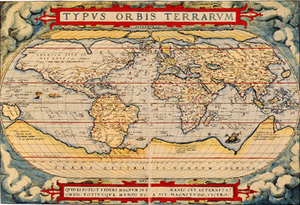
THEATRVM
ORBIS TERRARVM
[Theater of the World]
|
by Abraham Ortelius
407x546mm(two-page spread), half cloth binding, 53 colored plate, a geographic
index, cloth case
With a Japanese commentary by Akio Funakoshi in a separate volume
Price 180,000 Yenü@ISBN978-4-653-02179-7
|
Abraham Ortelius (1527-1598), Flemish geographer, of
German origin. Next to his contemporary Mercator, he is the most renowned
of the 16th-century Flemish school of geography. He traveled with Mercator
in 1560 and was thus inspired to begin his chief work, Theatrum orbis
terrarum in 1570, the fi rst modern atlas of the world. The first edition
of this atlas contained 53 maps, in part compiled from maps of 87
cartographers. This reprints 1570 Antwerp edition possessed in Leiden
University Library.
This magnificently reproduced atlas offers specialist and
non-specialist rare chance of examining essence of this old masterüfs
monumental work. |
[Facsimile reprint of 1570 Antwerp
edition, possessed by Leiden University Library]
 |
|
|
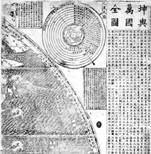
KUNYU WANGUO QUANTU
(Konyo Bankoku Zenzu)
[Map of the Ten Thousand Countries] |
by Matteo
Ricci
500x700mm, collotype print, 32 sheets of divided full -scale plates in
monochrome, 2 size-reduced maps with the dividing lines, cloth case, with
a Japanese commentary by Takeo Oda and Motohide Akiyama in a separate
volume.
Price 125,000 Yenü@ISBN978-4-653-03283-0 |
Father Matteo Ricci (1552-1610) was the first Italian
Jesuit to enter China. No person from the West had been such an infl uence
upon that country. He was the first to introduce Western science into
China and the first to penetrate to Peking. Ricciüfs genius was in playing
upon the Chinese reverence for learning. In astronomy, in prognosticating
eclipses, in horology, and in cartography, the Jesuit scientist supplied a
need and secured the respect and patronage of the Chinese Emperors. His
first
world map was made sometime before the end of 1584, as a Chinese version
of the European map hanging on the wall of the room. But no copy survives
of this fi rst edition.
Nor are any copies of Ricciüfs 2nd edition made in Nanking in 1600 at the
request of a prominent Mandarin.
Our reprint edition is based on the 3rd world map published at Peking
in 1602. This copy is one of five earliest surviving copies, located in
Miyagi Prefectural Library as national important cultural assets. The
oval projection of the 1602 map follows broadly that of the Abraham
Orteliusüfs Typus Orbis Terrarum, with the important alteration that China
is placed in the center of the map.
Original copy was designed to fit a folding screen measuring some 3780mm
by 1716mm, comprising six panels, each 631mm by 1716mm.
In this reprint copy, the whole map is divided into 32 sheets, each 480mm
by 700mm. 2 sheets of reduced maps of the whole map, 20 pages of
explanatory note in separate volume are included.
Scholars, students, and anyone, who are interested in early world map and
early missionary history in Asia, will find this magnifi cent reproduction
invaluable resource. |
[Facsimile reprint of 1602 Peking
edition, possessed by Miyagi Prefectural Library] ü@
 |